
I wanted to share the most recent iteration of my Google Map of the 1863 Civil War fortifications that circled Raleigh, NC. Since I posted the first version in January 2020, I’ve added many photos of the current locations of the entrenchment lines and artillery emplacements (redans, or batteries). I’ve also flagged a number of earth mounds and topographical features which might or might not be related to the original earthworks, but which I think ought to be investigated.
Keep in mind that this is an initial effort, and can likely be improved upon in terms of precision. The process of correlating a 150-year-old map with the modern landscape involves some risk of error. I think many locations on this map are accurate with 50 feet or less. For some locations, though, I estimate a possible error of 100 or even 200 feet.
Here’s a direct link to the Google Map: https://www.google.com/maps/d/edit?mid=18wH-6qk3Uuwp6Lj3qWudsWGYiLY3Qae0&usp=sharing
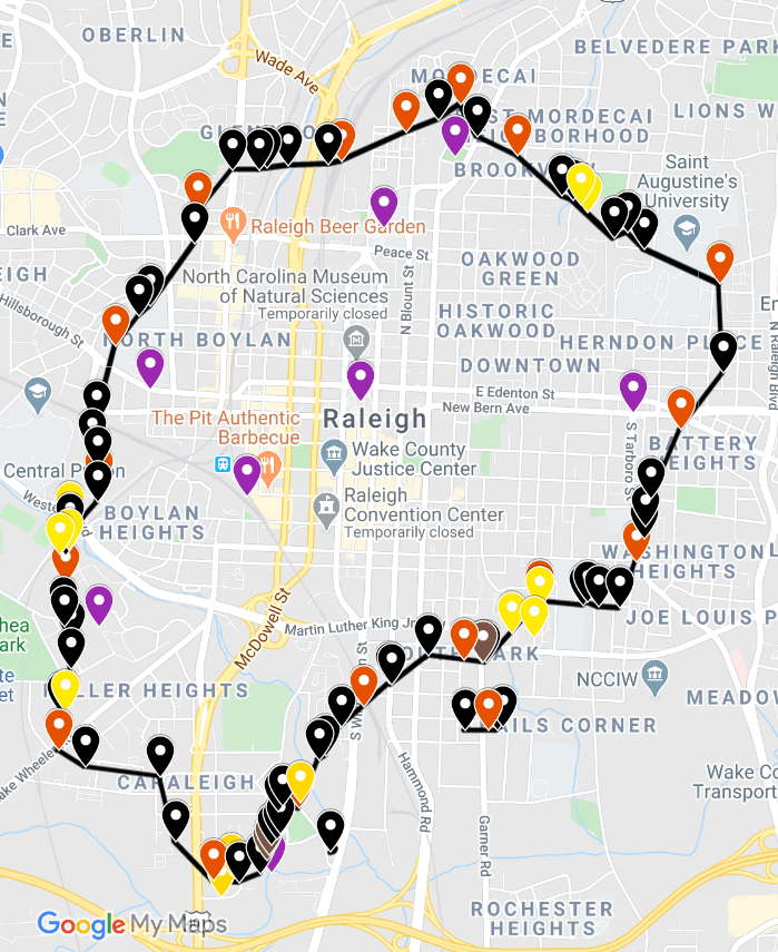
And here’s a screen shot of the map, so you can get an idea what it looks like. I will also make this image clickable, so you can click right through to the Google Map.
ARB — 12 Aug 2020

Al- This is a very cool project. Thanks for sharing it. As you are probably aware, some members of Raleigh CWRT tried to find surviving remnants of the fortifications without success in 2006. I still have copies of documents from those efforts as well as a Master’s thesis written by Thomas F. Higgins III in 1985 for the Anthropology Department of College of William & Mary. Have you seen this material? I have prepared several presentations on the occupation of Raleigh by Sherman in 1865 and on NC railroads during the Civil War focusing on specific sites where events occurred. You may have seen the latter Monday evening at the Raleigh CWRT Zoom meeting. If you missed it, it is now available at http://www.raleighcwrt.org located in the “Navigation” column in “Monthly Meeting Videos” (As I was presenting and hosting both, I could not identify all the participants.) I am sure other RCWRT members would be interested in learning of your work. Would you be willing to make a presentation to our group at a future date and/or make the map available through our website? I am unaware of what arrangement you might have with WordPress.com for this material. Ted Ted KunstlingPresident, Raleigh CWRT
LikeLiked by 2 people
I’ve talked to a general contractor who dug in the area of Mordecai (NW of Escazu) where the NW part of this breastwork existed and during one of the wars (wwii?) they filled them in, as it was a temporary camp, with leftover chemicals so that the dirt was purple! This contractor had to get them tested for safety of his workers and a local soil expert told him it used to be the breastworks trenches. Anecdotal, 3rd person. I have walked the areas in Dix west of Richardson and Ruggles and seen what looked like a flattened raised area that were in line with the heights which would overlook the west, south west plains. I assume, logically, such works were put on heights overlooking the approaches, so this is easy ground to walk and inspect (esp now that its a park). I also know a guy named Dennis Perry who grew up in Raleigh and played at the breastworks just west of Glascock St and Wake Forest Rd (there is a historical sign on Wake Forest there indicating 1/3 mile west ) as that building on the corner was a hospital where his aunt was a nurse, so he was brought there sometimes and went out to play (in the 60s) Cool fun, love that Civil War map. Of interest to me are things like the house of Devereaux in what is now Brooklyn subdivision and the baseball field that used to be along Pidgeon Cr. to the east (west of where Peace & Capital meet, south of Wade) That area will be redeveloped soon into a park.
LikeLiked by 2 people
Denis,
Thanks so much for your reply. I’ve driven and walked all of the areas you mentioned here, so it’s exciting to hear from someone who knows the ground and actually has anecdotes to share! I had never heard that about the trenches near N Blount St. Since the new apartments were built in that area, I think there’s little likelihood of finding any remnants just there. However, in the longer stretch between Oakwood and Capital Blvd, there are some areas where some remnants might be found, if not above ground then not far below. There are some of us who are interested in initiating archaeological studies that might reveal some of the locations of the batteries and entrenchments.
The Dorothea Dix area is promising, as it is in the hands of non-profit/governmental organizations. Plans for the park could beneficially include some historical and archaeological investigation of some promising areas there.
It’s interesting that you mentioned the works that were in the area of Mary Elizabeth Hospital (now medical offices) on Wake Forest Rd. I found a pension application from an enslaved worker who was conscripted to work on the entrenchments and mentioned being assigned to the works in that area. His account was written many years later, and he specifically mentioned the location where Mary Elizabeth was later built. (Off-topic, but I was born there!)
The Devereux area is fascinating as well. I think I have identified about where the Wills Forest house would have been. I plan to post an article here about that soon, since the 1863 map seems to show Devereux structures very near the entrenchments.
— A. Roy Bredenberg
LikeLiked by 1 person
[…] As followers of this website know, I’ve created a Google Maps version of the 1863 Raleigh Civil War fortifications. This map has allowed us to better pinpoint Civil War-era locations on the modern landscape. I’m referring to this Google Map as preliminary, since I think a more precise version is possible. Nevertheless, I think it’s accurate within 100 feet of most locations and thus very useful for exploration. For more details about the map, see this write-up: https://raleighswall.wordpress.com/2020/08/12/updated-google-map-of-raleigh-civil-war-fortifications… […]
LikeLiked by 1 person
I had been attempting to georeference the Raleigh fortifications myself but your work is so much better. This is a tremendous contribution to the (often overlooked) last days of the Civil War in NC. I have some data related to the US 20th ac and their march to Raleigh in April 1865 that might interest you. Thank you again for this outstanding resource.
LikeLike
Thanks again. I think there’s more that could be done with mapping studies, but most valuable would be archaeological studies of the existing above-ground remnants, along with radar studies and shovel testing to determine the locations of the entrenchments more precisely.
LikeLike
I agree and wish there was more interest from local universities in documenting and preserving that history. Apologies for the redundant comments by the way! I would love to privately share some of the data I have with you –hopefully it would be useful. It consists of GPS coordinates of relics recovered from one encampment of the 20th AC. Currently it’s all in ArcGIS but I could export to KML/KMZ or whatever convenient.
LikeLike
I’d love to discuss this with you. I will send an email — I believe I received your address along with this comment.
LikeLike