
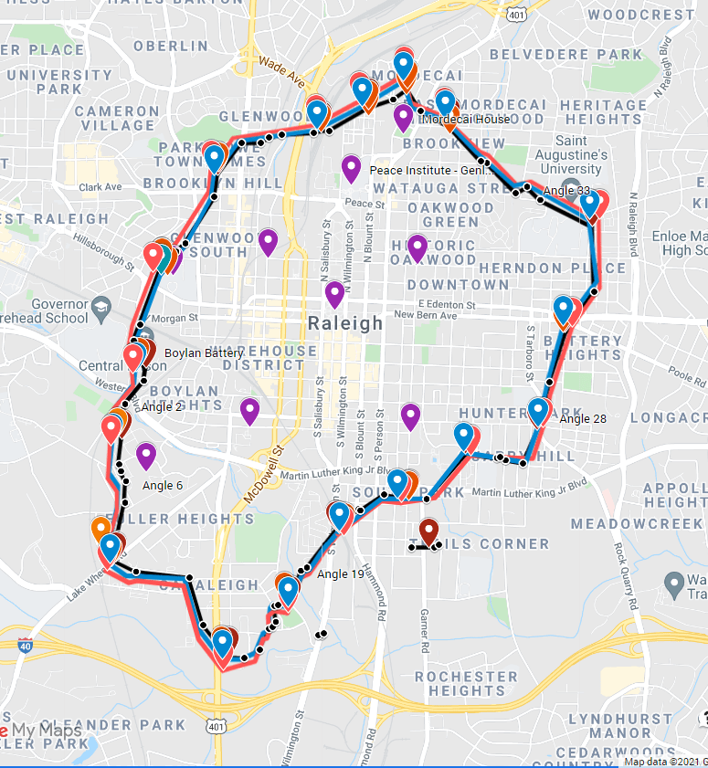
Recently I completed a new Google map of the Raleigh Civil War entrenchments, based on what I believe to be a more accurate takeoff of the original 1863 survey by the entrenchments’ designer, CSA Lt Col Henry T. Guion. You can access the map via this link:
Besides developing what I think is a more accurate map, based on anchor points on the Raleigh street grid, I have also included the mapping study completed earlier this year by a team from Richard Grubb & Associates, a cultural resources historical and archaeological firm. If you zoom in on the lines of entrenchments marked on the Google map, you will see three lines, which all correspond very closely and rarely vary more than 200 feet. My mapping study is marked in black. Grubb’s study is marked in blue and red, blue representing a takeoff of the original 1863 Guion map; red representing the lines on the 1865 Drayton map, which I believe to be a copy of the Guion map.
Below is a detail showing how to identify these three studies on the Google map. Also, I have indicated how to switch “Base map” views so as to examine the map in street view, satellite view, and other modes:

Here’s a screen shot of the overall fortifications map. This image is clickable and will lead you to the live version of the map:
As always, I’m very interested to see comments from readers, so please feel free to add your thoughts or questions below.
ARB — 19 Oct. 2021

Read the WRAL article today (July 9, 2023) where they mention you and the civil war rocks. They didn’t mention the rock on the other side of Western thought, on the Prison grounds. Just down the right side embankment as you turn into the prison entrance off Western if you are going west on Western. It has carvings on it. Visible before they redid that whole area with the new parking lot about 15 years ago. Curious, what was that map in the article?
Link:
https://www.wral.com/amp/20946624/
LikeLike
Glad you read the article, and thanks for commenting here! The writer did mention the rock over on Central Prison property, but she referred to it only as “One of the boulders, hidden in the woods along inaccessible property” — maybe intentionally vague, as security is tight over there. If you’re asking about the historical map that appeared in the WRAL article, that is the 1865 Drayton map drawn by Federal engineers after the surrender of Raleigh. That was a copy of the 1863 Guion map used for construction of the earthworks. If you explore this site, you’ll find those original maps, as well as interactive Google maps that lay them out on the modern landscape. The Drayton map is accessible here: https://raleighswall.com/2019/06/19/map-of-the-rebel-lines-at-raleigh-nc/
ARB
LikeLike
I had been attempting to georeference the Raleigh fortifications data myself but your work is just incredible and a huge contribution to the (often overlooked) history of the end of the Civil War in NC. If interested, I have some data to share related to the US 20th AC and their march on Raleigh in April. Thank you again for this tremendous collection!
LikeLike
Thanks for visiting here and for your comment! I’d be interested to hear more about the data you have.
LikeLike
Outstanding work! Thanks 🙂
LikeLike